| Amplitude | Day | Ex Meridian | Exercises | Pole Star | |
| Naut. Almanac |
Celestial Navigation
Exercises
Latitude by
Date: 31.10.1998.
Sext Altitude: 57°25’
Star:
Acrux
Declination:
63°05.3’S
Bearing:
South of observer
IE:
3.3’ OFF the arc
Height
of Eye: 6 m
Latitude: ??
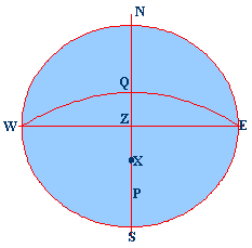
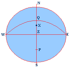
NESW is the
rational horizon P is the pole
Z is the
Zenith X is the Star WQE is the
celestial equator WZE is the
prime vertical NZS is the observer’s
meridian ZX is the
zenith distance SX is the
true altitude PX is the
polar distance QX is the
declination PZ is the
co-Lat. QZ is the
Latitude
Correct the Altitude:
Sext. Alt.: 57°25.00’
IE: + 3.3’
(OFF)
Observed Altitude: 57°28.3’
Dip: (-) 4.3’ [Dip
(in minutes) = 1.76√Height of Eye (in metres)]
57°24.0’
Refraction: (-) 0.6’
True Altitude: 57°23.4’
(-) 90°00.0’
True Zenith Distance: 32°36.6’N
Declination: 63°05.3’S
[Same names add, different names subtract]
Latitude: 30°28.7’S
Calculating the
Date: 01.11.1998.
Sext Altitude: 57°25’
Star:
Altair
Declination:
08°52.1’N
Bearing:
South of observer
IE:
2.0’ ON the arc
Height
of Eye: 7 m
DR
Latitude: 44°14.0’N (approximate)
DR
Longitude: 158°00.0’E
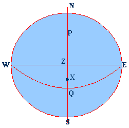
NESW is the
rational horizon P is the pole
Z is the
Zenith X is the Star WQE is the
celestial equator WZE is the
prime vertical NZS is the
observer’s meridian ZX is the
zenith distance SX is the
true altitude PX is the
polar distance QX is the
declination PZ is the
co-Lat. QZ is the
Latitude
Correct the Altitude:
DR Latitude: 44°14.0’N
Declination: 08°52.1’N
[Same names subtract, different
names add]
{Since this is reverse calculation to find the
altitude, the add / subtract rules change}
Approx. MZD 35°21.9’N
(-) 90°00.0’
Approx. True Altitude: 54°38.1’
S
Refraction: (+) 0.7’ Reversed
signs since we are doing the calculation backward
Dip: (+)
4.6’ [Dip (in minutes) =
1.76√Height of Eye (in metres)]
IE: + 2.0’ (ON) this is not reversed, since this a equipment fault
Approx. Sext. Alt.: 54°45.4’S
Latitude by
Below the Pole
FINDING THE LATITUDE
Date: 06.11.1998
Sext Altitude: 15°08’ North of the
observer
Longitude:
158°00.0’E
Star:
Alioth
Declination:
55°58.0’N
Bearing:
North of observer
IE: 1.6’
OFF the arc
Height
of Eye: 10 m
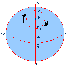
NESW is the
rational horizon P is the pole
Z is the
Zenith X is the Star
below the pole WQE is the
celestial equator WZE is the
prime vertical NZS is the
observer’s meridian ZX is the
zenith distance PX is the
polar distance QX is the
declination PZ is the
co-Lat. NX the True
Alt. Below the pole QX1 is the
declination NP is the
Latitude
Declination: 55°58.0’N
(-) 90°00.0’
Polar Distance: 34°02.0’
Sext. Alt.: 57°25.00’
N
IE: + 1.6’ (OFF)
15°09.6’
Dip: (-) 5.6’ [Dip
(in minutes) = 1.76√Height of Eye (in metres)]
15°04.0’
Refraction: (-) 3.6’
True Alt.: 15°00.4’
N
Polar Distance:(+) 34°02.0’
Latitude: 49°02.4’N (Explanation See figure)
Important: When
the object is on the meridian below the pole it always bears North in North
Lat., and South in South Lat. Or you may say that the Latitude always has the
same name as the bearing of the object.
Latitude by
Below the Pole
FINDING THE ALTITUDE
Date: 31.10.1998.
DR
Latitude: 48°04.0’ S
DR Longitude:
120°00.0’E
Star:
Achernar - Below the Pole
Declination:
57°14.7’N
Bearing:
North of observer
IE:
1.5’ ON the arc
Height
of Eye: 8.5 m
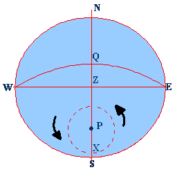
NESW is the
rational horizon P is the pole
Z is the
Zenith X is the Star
below the pole WQE is the
celestial equator WZE is the
prime vertical NZS is the
observer’s meridian ZX is the
zenith distance PX is the
polar distance QX is the declination PS is the
Lat. PZ is the
co-Lat. NX the True
Alt. Below the pole NP is the
Latitude SX is the
Altitude.
Declination: 57°14.7’N
(-) 90°00.0’
Polar Distance: 32°45.3’
DR Latitude: 48°04.0’S
Polar Distance: 32°45.3’ (Explanation See figure)
Approx. True Altitude: 15°18.7’
Refraction: (+) 3.4’Reversed signs since we are doing the
calculation backward
Dip: (+) 5.1’ [Dip
(in minutes) = 1.76√Height of Eye (in metres)]
IE: +
1.5’ (ON) this is not reversed, since
this a equipment fault
Approx. Sext. Alt.: 15°28.7’S
SUN
Latitude by
The sun is on the observer’s meridian at
The Local Mean Time of the MP at
The above
is the approximate time of MP at any other meridian.
Process:
Take down the time of MP of the Sun: Name it Local
Mean Time of MP
Convert the Longitude into Time – Long. (W) (+) and
Long. (E) (-)
Add or subtract the Longitude in time from the LMT to
get the GMT of the MP
Look up the Almanac to get the Sun’s declination –
correct it as required.
Find the TZD from the T.Alt.
Add or subtract the declination to the TZD to get the
Latitude.
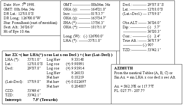
Date: 06.11.1998.
00h 12h Equation Of time 06th------------------- 16m23s 16m22s Equation of time 07th------------------- 16m21s 16m19s LAT (ship)--------------------------------- 12 00 00 Long. WEST-------------------- (+) 02 11 00 Equation of Time-------------- (+) 16 22 GMT (
Sext Altitude: 63°50.0’ North of Observer
Now
interpolate for --------------------- 14h
11m 00s
Bearing:
North of observer
IE:
3.3’ OFF the arc
Height
of Eye: 7 m
![]()
Latitude: ??
Longitude:
032°45.0’W
NESW is the
rational horizon P is the pole
Z is the
Zenith X is the Star WQE is the
celestial equator WZE is the
prime vertical NZS is the
observer’s meridian ZX is the
zenith distance NX is the
true altitude PX is the
polar distance PZ is the
co-Lat QX is the
declination ZQ is the
Latitude. QZ is the
Latitude
Correct the Altitude:
Sext. Alt.: 63°50.0’
IE: + 3.3’ (OFF)
Observed Altitude: 63°53.3’
Dip: (-)
4.8’ [Dip (in minutes) = 1.76√Height of Eye (in metres)]
Convert the Longitude into Time. Divide the Longitude by 15° So, 032°45.0 = 02h 11m GMT = MP + Long. (W) D H M LMT 06 11 44 Long W + 02 11 GMT 06 13 55
63°48.5’
Refraction: (-) 0.5’
63°48.0’
Parallax: (+) 0.1’
Semi Diameter: (+) 16.2’
True Altitude: 64°04.3’
(-) 90°00.0’
True
Zenith Distance: 25°55.7’ (ZX)
Corrected Declination:
S 16°01.3’ (QX)
Latitude: 41°57.0’ (ZQ)
SUN
FINDING THE LONGITUDE
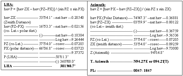
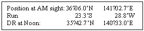
Date: 03.11.1998. Time: ------------------ 0800 DR Latitude: ---------- 32˚06.0’N DR Longitude: -------- 140˚54.0’E Chron. Time: --------- 03d 22h 02m 07s Chron. Error: SLOW----------- 00m 40s Sext Altitude: --------- 36°01.0’ (sun LL) IE: --------------------- 3.6’ ON the arc Height of Eye: -------- 12.2 m
Chron. Time:--------------- 03 22 02 07 SLOW----------------------- (+) 00 40 GMT------------------------- 03 22 02 47 GHA
(sun) For 22h------- 154˚06.3’ Incr.For 02m 47s---------- (+) 0˚41.8’ GHA
------------------------- 154˚48.1’ Decl--------------------------
15˚12.7’S -------------------------------- (-)
90˚00.0’ Polar
Distance ------------ 74˚47.3’
(PX) PZ – PX---------------------
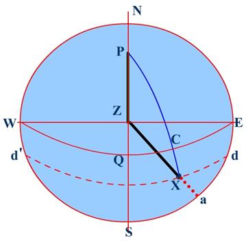
16˚53.3’ PZ – ZX--------------------- 03˚59.9’ NESW is the
rational horizon P is the pole
Z is the
Zenith X is the Sun WQE is the equinoctial WZE is the
prime vertical NZS is the
observer’s meridian ZX is the
zenith distance NX is the
true altitude PX is the
polar distance CX is the
Declination aX is
the altitude PZ is the
co-Lat Angle ZPX is the Hour Angle Angle PZX is the
Azimuth Known: PZ, PX, AND ZX. To find: angle P and angle Z
Correct the Altitude: [Dip (in mts) =
1.76√Height of Eye (in m) Sext. Alt.(LL):------------ 36°01.0’ IE:-------------------------- (-) 3.6’ (ON) ----------------------------- 35°57.4’ Dip:------------------------- (-) 6.2’ ----------------------------- 35°51.2’ Corr. (Almanac)---------- (+) 14.7’ True Altitude:------------- 36˚05.9’ ------------------------ (-) 90°00.0’ True Zenith Distance:---- 53°54.1’ (ZX) Latitude:----------------- 32˚06.0’N ------------------------ (-) 90°00.0’
Co-Lat. 57°54.0’ (PZ)
Longitude = LHA ~ GHA LHA (sun):-------- 301˚48.7’ GHA (sun):-------- 154˚48.1’ ----------------------- 141˚02.7’
E Obs.
Longitude:----------- 147˚00.6’
E
Once the Longitude has been found out, the position
line that has been obtained is plotted on the position of DR Latitude and the
Observed Longitude.
From the above calculation it is apparent that the DR
Latitude plays an important part in determining the observed Longitude, thus if
the position of the DR Latitude is in error then the obs,
Longitude will be way out.
However the Azimuth will not be since a slight error
in Latitude will not make much difference in the Azimuth.
WORKING ON BOARD:
In ancient times – before the advent of GPS, the sight
of the sun was of paramount importance, since this was one of the primary means
of locating the position of a ship. Observation of stars was not that fortunate
because the horizon had to be good and the cloud cover negligible.
The Sun as a result was observed in the Morning at
around 0800h and the Longitude obtained. At
In this we would be using the figures as obtained in
the above example.
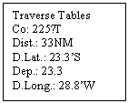
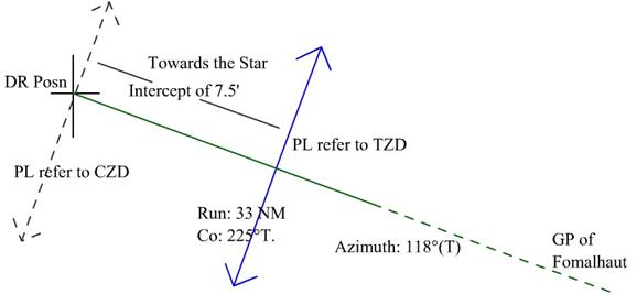
After
the Sun was observed in the morning the Ship sailed a distance of 33 NM on a
course of 225˚T.
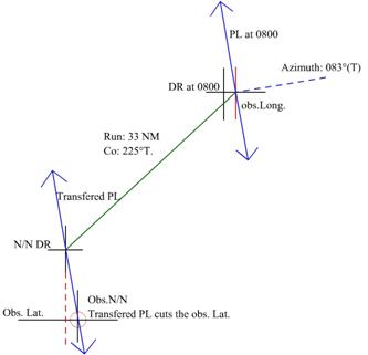
Principle
of Position Lines
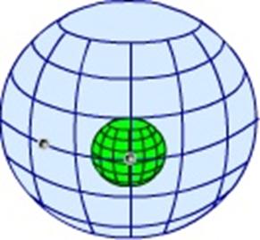
Celestial Sphere Showing the
Earth and the 2 stars. The
projected spots of the stars on the surface of the Earth
In the
above we see two heavenly bodies as viewed from the earth,
they are projected on the imaginary celestial sphere. The positions of the two
bodies if projected on the earth would be at their respective GP’s as shown in
the other figure (marked as X)
We may assume any latitude or longitude of the GP’s of
the two bodies.
Now with the True Zenith Distance as observed, we may
draw a circle with radius equal to that of the TZD on the surface of the Earth.
Then at every point on the circle the observed
altitude (true) would be the same since it is a circle of equal TZD of that
body.
However distant a ship may be as long as the location
of the ship is on the circumference of the circle the TZD as found would be the
same.
Let us now assume the following that the body has a
declination of 20°N and a GHA of 2 hours, then this body’s GP would be at lat.
20°N and Long. 030° W.
Let the body as observed have a true altitude of 70°, then the TZD would be 20°
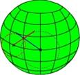
A ship from which the bearing of the body is due North
would be on the equator and on the same meridian as the body. That is the ship
would have a position of Lat. 00° and Long. 030°W. This because the line of bearing, North cuts the circle at a
definite position.
However from another ship if the same body is observed
as bearing 180° then that ship would be on a parallel of latitude that is 20°
due north of the GP of the body, or the Latitude of the ship would be 40°N. The
longitude would be same at 030°W. This because the line of
bearing, South, cuts the circle at a definite position.
Again if another ship observes the body on a bearing
of 116° True then, this line of bearing would cut the circle at the ships
position as shown in the figure.
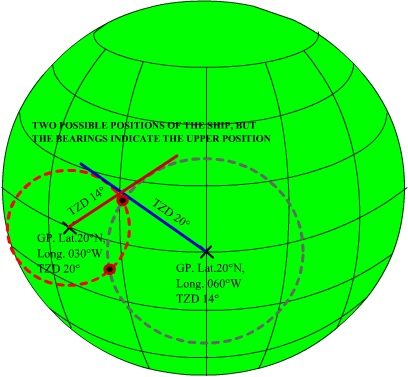
If this above ship takes another observation now of a
different body whose declination is the same at 20°N but the GHA is at 4 hours,
its GP would be would be lat. 20°N and Long. 060°W.
Let the TZD as obtained from the observed altitude to be 14° and the bearing
from the ship as 225°. Then the ship’s position as referenced to this body
would lie on the dotted line where the dotted line cuts the circle.
Thus if a ship observes two or more bodies at the same
time (nearly) the points of intersection of the bearing lines would give the
position of the ship with some degree of accuracy. However the points intersect
at two opposite directions, thus the bearings of the bodies from the ship would
determine the exact position of the ship.
So far so good.
But we cannot draw such huge circles and accuracy
would suffer. So instead of drawing the circles what we do instead is we draw a
part of the arc, this arc although a curved line may be assumed to be a
straight line for a very short length.
The question is now of fixing the centre of the body,
this is overcome by estimating the position of the ship – that is using the DR
position of the ship.
Now since the body/ bodies are observed from this DR
position the line of bearing would pass through this position.
The Zenith Distance of the body is calculated for the
time of observation, and the Zenith Distance as obtained from the observation
of the altitude is compared.
Or the CZD is compared with the TZD.
If the TZD and the CZD are the same then the Ship is
at the position of the DR. The arc of the circle (which is drawn as explained
earlier with the radius as the TZD) would be drawn at right angles to the line
of bearing (since the radius always cuts the circumference at right angles –
the arc of the circumference being a straight line as assumed). If two or more bodies have
been observed and assuming that the ship was stationary during the observation
(there being absolutely no movement of the ship) and also that the observer was
a genius at sights then theoretically the arcs (straight lines representing the
arcs) would all intersect at exactly the DR and the DR would be the observed
position of the ship.
However if the arcs do not intersect then the point at
which they do intersect becomes the observed position of the ship.
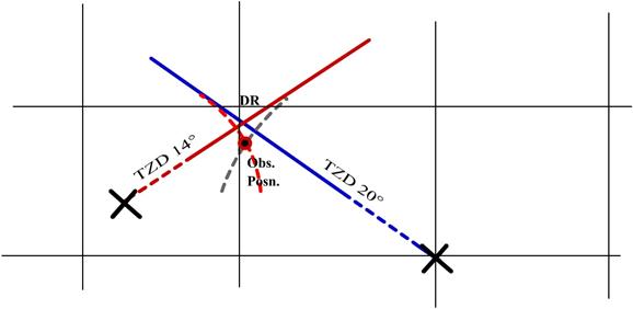
But when comparing the CZD
and the TZD, the difference, called the ‘Intercept’ may be +ve
or –ve.
Or we may say that CZD is more than TZD by a value or
the reverse. In that case how do we draw the line of bearing and where do we
place the arc of the circle of position?
First we mark the DR of the ship and the bearing lines
are drawn since the DR position is close to the actual position and the bearing
was taken from that location the bearing line would pass through the DR
position.
Now the question where do we draw the arc (straight
line) on the bearing line, obviously it will be at right angles to the bearing
line as a radius always touches the circle at right angles.
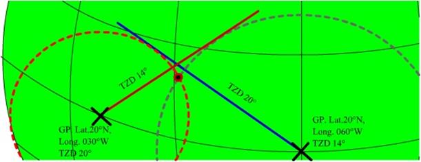
Modifying the figure for ease in drawing on the chart
paper, we have:
Here we see that the Body positions are very far in
the distant – the dotted lines indicate this.
Also the arcs are shown as arcs, but when we draw on the
ship we would use straight lines. Also the arcs are drawn centered on the
bodies. Whereas the arcs or the straight line we would be drawing would be
centered on the DR position.

What has been shown above is the observed position as
plotted with the TZD, but this again is not possible on the ship, since we
still cannot plot the GP of the bodies.
Thus on the ship we first calculate the Zenith
Distance for the time of observation using the details given in the Almanac.
Next we find the true altitude and obtain the True
Zenith Distance.
Next we compare the CZD with the TZD. If we have the
CZD is greater than the TZD then:
The ship is somewhere on the approx. arc of CZD, the
actual position is however on the ARC of the TZD circle.
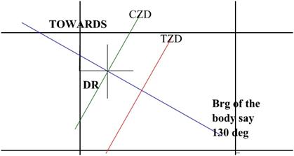
In the above since the CZD (estimated) radius is more
than the actual radius that is the TZD, therefore the ship has to be on the arc
TZD, so we term this difference between the CZD and the TZD as TOWARDS, that is
we are moving towards the body for accuracy.
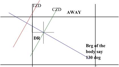
If however the TZD had been greater then the Ships
position would have to be shifted on to the TZD arc which being greater, meant
that the ship was being moved AWAY from the body.

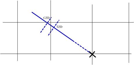
Summing up:
For plotting we first calculate the CZD using the time
of sight and the Almanac, the ship is on the arc drawn with the CZD as radius –
this is the assumption.
Next we calculate the TZD using the observed altitude.
We compare the two, and find which one is greater, if:
CZD is greater than TZD then the difference
(Intercept) is termed TOWARDS
TZD is greater than CZD then the difference
(Intercept) is termed AWAY.
If two or more bodies were observed then the ship
would lie at the intersection of the arcs – Position Lines.
After the above position lines have been drawn, the
intersection of the position line forms the position at which the ship was at
the time of observation.
This plotting may be done on any chart (old and cancelled – preferably of a region close to the equator)
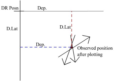
The intersection position is now measured with
reference to the DR.
The distance above or below the DR is measured using a
fixed scale, which was used for the initial marking of the Intercept. And the
distance so measured is considered as the Difference of Latitude to the DR
latitude.
The distance east or west of the DR is considered as
the departure from the DR Longitude.
Applying the D’lat we find
the OBS. LATITUDE.
Using Traverse table and the mean of the two latitudes
we can convert the Departure measured into Difference of Longitude and applying
this to the DR Longitude we would get the OBS. LONGITUDE.
In general working the scale used is the Longitude
scale, since the Longitude scale remains constant on a Mercator chart but not
the Latitude scale.
NOTE: The time interval between the sights of the
bodies if too long then run between the individual sights have to be applied,
however if the entire time period is less than 3 minutes then the run interval
may be omitted due to the distance run being insignificant. Practicing the
shooting of the stars, makes taking up to 4 stars complete, within 3-4 minutes.
The Marcq St. Hilaire method of
fixing the position of the Ship
(Also known as the Intercept method)
In
this method the TZD is compared with the CZD and the Intercept is found out.
The position of the PL may have to be drawn Towards
the body or Away from the body.
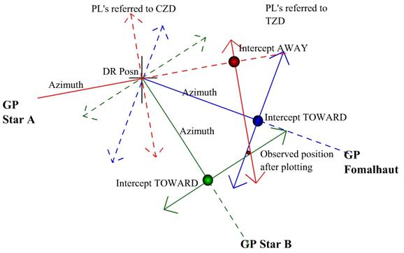
Let us now assume that another two stars were observed
at an interval of time of 30s – say practically the same time.
The DR used for calculation remains the same.
We have Fomalhaut with an
azimuth of 118˚T giving a PL of 028˚ - 208˚ and with an
Intercept of 7.5’ Towards
Say star A had an azimuth of 255˚ giving a PL of
165˚ - 345˚ and had an Intercept of 16.0’ Away
And star B had an azimuth of 135˚ giving a PL of
045˚ - 225˚ and had an Intercept of 24.0’ Towards
Apply the D.Lat to the DR
Lat. To obtain the Observed Latitude
Use the Traverse Tables to get the D.Long for the
measured Departure using the mean Lat.
Apply the D.Long to the DR Long. To get the Observed
Longitude
IF THE STAR OBSERVATION CANNOT BE TAKEN AT THE SAME
TIME AND THEY ARE OBSERVED WITH A LARGE INTERVAL OF TIME THEN RUN HAS TO BE
APPLIED, ALL THE STARS HAVE TO BE WORKED WITH DIFFERENT DR’S AND THE PL
OBTAINED WOULD HAVE TO BE SHIFTED TO THE MEAN TIME OF SIGHT AS SELECTED, TRANFEREING
PL’S AS SHOWN EARLIER ON,