| Wind Pressure Sys. | Structure of a Depression | Anticyclone | Weather Services | TRS |
Meteorology
Wind and Pressure Systems
The diagram below shows the distribution of pressure
and the winds, which would result over a featureless earth.
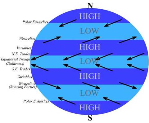
The Trade Winds blow on
either side of the Equatorial Trough, NE’ly in the N
hemisphere and SE’ly in the S hemisphere.
The Trades blow with great persistence and each
embraces a zone of some 1,200 miles of latitude.
Trade winds, however, do not blow throughout this
zone.
The South West Monsoon winds blow instead off part of
the West coast of
The trades move slightly north and south with the sun;
their approximate limits are as follows:
February August
Atlantic
Doldrums 000° - 002°N 005°N - 010°N
N.E.
Trade 002°N - 025°N 010°N - 030°N
S.E.
Trade 000° - 030°S 005°N - 025°S
Pacific
Doldrums 004°N - 008°N 008°N - 012°N
N.E.
Trade 008°N - 025°N 012°N - 030°N
S. E.
Trade 004°N - 030°S 008°N - 025°S
Indian
S.E. Trade 015°S - 030°S 000° - 025°S
The ANTI-TRADES are winds, which blow above about 2500
metres in the opposite direction to the trades on the surface.
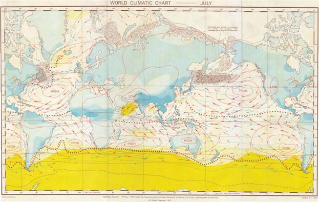
Climatic Chart for July
The average strength of the Trades is about Force 4,
though variations occur between different oceans and at different seasons.
The weather in Trade Wind zones is generally fair with
small-detached cumulus clouds.
On the E sides of the oceans cloud amounts and
rainfall are small, while on the W sides cloud amounts are larger and rainfall
is frequent, being a maximum in the summer months.
Cloud amounts and the frequency and intensity of rain
all increase towards the Equatorial Trough.
Poor visibility often occurs at the E end of the Trade
Wind zones, due partly to mist or fog forming over the cold currents and partly
to sand and dust being carried out to sea by prevailing offshore winds.
At the W end of the zones visibility is good, except
when reduced in rain. Fog is rare.
In certain seasons and in certain localities the
generally fair weather of the Trades is liable to be interrupted by tropical
storms. These are described in detail
later.
The Variables
Over the areas covered by the oceanic anticyclones,
between the Trade winds and the Westerlies further
toward the poles, there exist zones of light and variable winds which are known
as The Variables, and the N area is sometimes known as the Horse Latitudes
(30°- 40°). The weather in these zones
is generally fair with small amounts of cloud and rain.
The Westerlies
On the polar sides of the oceanic anticyclones lie
zones where the wind direction becomes predominantly W’ly. Unlike the Trades, these winds known as The Westerlies are far from permanent. The continual passage of depressions from W
to E across these zones causes the wind to vary greatly in both direction and
strength. Gales are frequent, especially
in w inter. The weather changes rapidly
and fine weather is seldom prolonged.
Gales are so frequent in the S hemisphere that the zone, S of 40°S, has
been named the Roaring Forties.
In the N hemisphere fog is common in the W parts of
the oceans in this zone in summer.
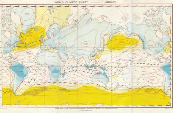
Climatic
Chart for January
Areas where fog is likely and those where ice may be
encountered are shown on the below in the climatic
charts:
The
SEASONAL WINDS AND MONSOONS
Over certain parts of the oceans the general
distribution of pressure and wind in the zones described above is greatly
modified by the seasonal heating and cooling of adjacent large,
landmasses.
The annual range of sea temperature in the open ocean
is comparatively small, whereas large landmasses become hot in summer and cold
in winter.
This alternate heating and
cooling of the land results in the formation of areas of low and high-pressure
respectively.
This redistribution of pressure results in a seasonal
reversal of the prevailing wind over the adjacent oceans.
The most important oceanic areas subject to these
seasonal winds are the
LAND AND SEA BREEZES
The regular alternation of land and sea breezes is a
well-known feature of most tropical and sub-tropical coasts and large
islands.
These breezes also occur at times in temperate
latitudes in fine weather in the summer, though they are here much weaker and
less well marked than is the case in lower latitudes.
The cause of these breezes is the unequal heating and
cooling of the land and sea. By day the
surface of the land rapidly acquires heat from the sun whereas the sea temperature
remains virtually unaffected.
The heat of the land is communicated to the air in
contact with it, which expands and rises.
Air from over the sea flows in to take its place, producing an onshore
wind known as a sea breeze.
By night, land rapidly loses heat by radiation and
becomes much colder than the adjacent sea.
The air over the land is chilled, becomes denser and heavier and flows
out to sea under the influence of gravity, producing an offshore wind known as
a land breeze.
Sea breezes usually set in late in the forenoon and
reach maximum strength, about force 4 (occasionally they reach force 5 or even
6), around 1400.
They die away around sunset.
Land breezes are usually less well-marked and weaker
than sea breezes. The effect of these breezes
may be to deviate the prevailing wind, reinforce it,
neutralize it or even reverse it.
The following factors favour the formation of
well-marked land and sea breezes:
(a) A dry
desert coast as opposed to forests or swamps.
(b) High ground near the coast.
(c) A weak prevailing wind.
(d) A clear or partly cloudy sky.
A cold current along the coast also has the effect of
favouring the establishment of a well-marked sea breeze.
Small islands less than 5 to 10 miles in diameter will
not usually produce land and sea breezes.
As the land is heated during the daytime the air over
it will be heated by conduction.
This heating causes a decrease in the density of the
air, and the pressure falls.
The sea temperature remains more or less the same and
the pressure over it is high compared with that over the land. The pressure gradient is sufficient for air
to flow from over the sea to the land; this is the sea breeze.
The sea breeze (about force 3 – 4) sets in during the
morning, reaches its maximum strength about 1400 hours and then dies away
towards sunset.
After sunset the land cools rapidly and the air above
it also cools and its density increases giving rise to an increase in
pressure.
The pressure over the sea is now low compared with
that over the land. The pressure
gradient causes air to flow from the land to the sea; this is the LAND BREEZE.
The land breeze (generally very light compared to sea
breeze) sets in shortly after sunset and continues until dawn.
N.E. MONSOON OF THE
During the northern winter the Asian continent is
cooled and an intense high pressure area forms over
The winds circulating round this form the N.E.
Monsoon.
In the northern part of the China Sea the pressure
gradient is large and winds are likely to be North Westerly force 6 - 7,
further south where the pressure gradient is smaller the winds will be
northerly force 5 - 6. In the
Rainfall of the showery type is likely on windward coasts especially in the
The N.E. monsoon becomes established in early December
and continues until April.
S.W. MONSOON OF THE
During the northern summer the Asian continent is
warmed and the high pressure over
There is a pressure gradient between the high pressure
over the
Away from the coast the wind is deflected to the right
and blows from a southwesterly direction.
In the
In the
The northern part of
The air forming the S.W. Monsoon his traveled over
thousands of miles of ocean and is saturated.
This results in heavy rain, especially near the
coasts, and poor visibility.
The S.W. monsoon sets in during the beginning of June
and lasts until the beginning of October.
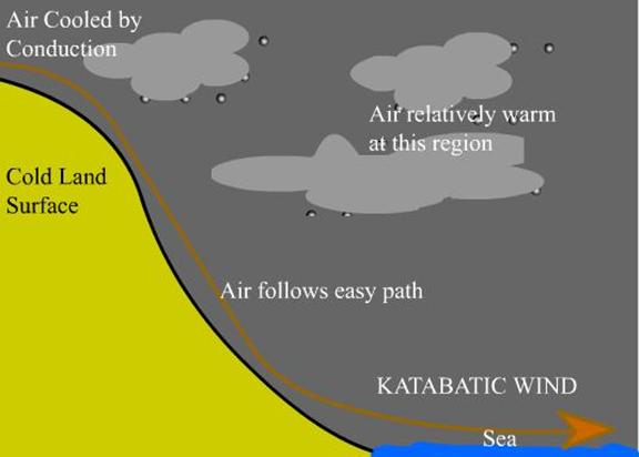
KATABATIC EFFECTS
Katabatic winds are
offshore winds caused by the drainage of cold air from high ground under the
influence of gravity.
In temperate and high latitudes, where snow-covered
mountains back the coast, intense radiation occurs and this causes cold air to
accumulate over the high ground. A light
offshore wind suffices to start this mass of cold air moving down the seaward
facing slopes with gathering momentum reaching the coast without warning, as a
strong Or even gale force wind, endangering small craft or ships at
anchor. The following are some of the
areas where Katabatic winds
are common:
When the earth’s surface cools by night, the air next
to the surface is also cooled and thus its density is increased. If this cold air is on high ground there is a
tendency for it to sink down- to lower ground. If the high ground is a cliff
top or a high coastal plateau, the down flowing cold-air will move horizontally
when it reaches sea level.
The ANABATIC
WIND is less noticeable as it blows up the sides of valleys with
considerably less force than the KATABATIC wind. The air at the bottom of the valley is warmed
by conduction from the heated land during the day, and this air, being less
dense than the air above it, takes the easiest path to the top of the valley by
following the warm sides.