| Wind Pressure Sys. | Structure of a Depression | Anticyclone | Weather Services | TRS |
Meteorology
Tropical Revolving Storms
Terms associated with a TRS
The air circulation's of the
Northern and Southern hemispheres are in opposite directions, so that
disturbances, which form in one hemisphere, cannot cross into the other
hemisphere.
The area near the equator is one of convergence as the
Northern Hemisphere N.E. Trade wind blows towards it, as does the S.E. Trade of
the Southern Hemisphere.
The general name for this area is the INTERTROPICAL
CONVERGENCE ZONE (ITCZ), also known as the DOLDRUMS.
When the ITCZ is well to the north or south of the
equator the change in direction of the trades after crossing the equator will
cause very strong convergence currents and it is possible that a cyclonic
disturbance will form in this area. The possibility is increased when the ITCZ
is in the vicinity of islands when local surface heating of air of high
humidity gives rise to very unstable conditions.
Low pressure areas frequently occur in the ITCZ but
cyclonic circulation can only result if the geostropic
force is sufficiently large (there is no geostropic
force on the equator) and this is unlikely in latitudes less than 5°.
The cyclonic disturbance once formed is known as a
Tropical Revolving Storm whose diameter varies between 50 to 800 miles, 500
miles being an average.
After formation between 5° to 10° of latitude the
storm moves westwards at 10 - 12 knots, until reaching the tropic, where3 it
slows down before re-curving eastwards and proceeding at 15 – 20 knots to the
higher latitudes.
TRS do not normally cross-land but when and if they do
the supply of warm moist air necessary to their existence being cut off they
tend to fill and thus dissipate. However if the TRS do cross over again from
land to sea then they again deepen.
Normally these occurrences are few and the land that
is crossed is small, but sometimes-powerful TRS can cross wide landmasses – as
wide as
It is noticed that the T.R.S. is not found in the
|
AREA |
NAME |
SEASON |
|
North Atlantic Ocean Western side |
Hurricane |
June to November |
|
North Pacific Ocean Eastern side |
Hurricane or Cordonazo |
June to November |
|
North Pacific Ocean Western side |
Typhoon or Raguios |
All the year but greatest frequency and intensity June to November. |
|
|
Hurricane |
December to April |
|
South Indian Ocean Eastern side |
Willy-willy |
December to April |
|
South Indian Ocean Western side |
Cyclone |
December to April |
|
|
Cyclone |
June and November but they may occur during the S.W. monsoon season. |
|
|
|
|
The following terms are in common use when reference
is made to a T.R.S.:
PATH: The direction in which the storm is moving.
TRACK: The area, which the storm centre has traversed.
STORM FIELD: The horizontal area covered by the
cyclone conditions of the storm.
SOURCE REGION: The region where the storm first forms.
VERTEX: The furthest westerly point reached by the
storm centre.
EYE OF THE STORM: The storm centre.
BAR OF THE STORM: The advancing edge of the storm
field.
ANGLE OF INDRAUGHT: The angle, which the wind makes
with the isobars.
VORTEX: The central calm of the storm.
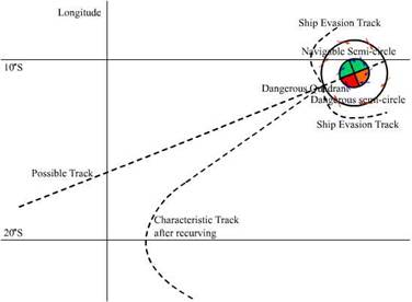
DANGEROUS SEMI-CIRCLE: The half of the storm, which lies
to the right of the path in the Northern Hemisphere and to the left of the path
in the Southern Hemisphere.
DANGEROUS QUADRANT: The leading portion of the
dangerous semicircle where
NAVIGABLE SEMI-CIRCLE: The half of the storm, which
lies to the left of the path in the Northern Hemisphere and to the right of the
path in the Southern Hemisphere.
TROUGH LINE: A line through the centre of the storm at
right angles to the path. The dividing line between falling and rising pressure.
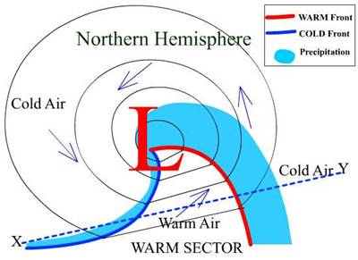
Oceanic
depressions usually have one or more fronts extending from their
centres, each front representing a belt of bad weather, ac companied by a veer
(backing) of wind, which marks the change from the weather characteristic of
one air mass to that of the other. During the first two or three days of its
existence a depression has a warm and a cold front, the area between the two
being known as the warm sector because the air has come from a warmer locality
than that which is outside the sector.
This is shown in the following diagram:
Depression Northern Hemisphere:
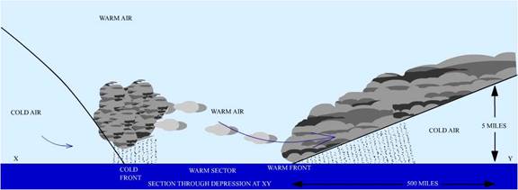
Warm air is lighter than cold air and rises over the
cold air ahead of the warm front as shown in the diagram:
These are intense depressions occurring in tropical
latitudes accompanied by high winds and heavy seas. Although the pressure at
the centre of a tropical storm is comparable to that of an intense mid-
latitude depression, the diameter of a tropical storm is much smaller (some 500
miles compared with 1,500 miles), and therefore the pressure gradients and the
wind speeds correspondingly greater.
The wind blows round the centre of a tropical storm in
a spiral movement inwards, anti-clockwise in the N hemisphere and clockwise in
the S hemisphere, giving rise to the occasional alternative name Revolving Storm.
Within 75 miles of the centre of a tropical storm, the
wind is often very violent and the sea high and confused, causing considerable
damage even to large and well-found ships. The danger is still greater when
ships are caught in restricted waters without adequate room to manoeuvre.
Due to torrential rain and sheets of almost continuous
spray visibility near the storm centre (but outside the eye) is almost nil. Within 5 to 10 miles of the centre the wind is light or
moderate and variable, the sky is clear or partially so, and there is a heavy,
sometimes mountainous, confused swell; this area is known as the eye of the
storm.
The localities, seasons, average frequencies and local
names of these storms are shown in the notes.
The locating of tropical storms has greatly improved
in recent years with the aid of weather satellites.
Once identified by satellite, tropical circulations
are carefully tracked and in some areas, e.g. the seas around the
Warnings of the position, intensity and expected
movement of each circulation -are then broadcast at regular intervals (see Admiralty List of Radio Signals).
Tropical storms generally originate between the
latitudes of 7° and 15°, though some form nearer the equator.
Those which affect the W part of the Pacific, South
Indian and
In the N hemisphere they move off in a direction
between 275° and 350°, though most often within 30° of due W. When near the
latitude of 25° they usually recurve away from the
equator and, by the time they have reached a latitude of 30°, the track (or
path as it is more usually called) is NE. In the S hemisphere they move off in
a WSW to SSW direction (usually the former), recurve
between latitudes of about 15° to 20°, and thereafter follow a SE path. Many
storms, however, do not recurve but continue in a WNW
(WSW) direction until they reach a large land mass where they fill quickly.
The speed of the storms is usually about 10 knots in
their early stages, increasing a little with latitude but seldom achieving 15
knots before recurving.
A speed of 20 to 25 knots is usual after recurving though speeds of over 40 knots have been known.
Storms occasionally move erratically, at times making a complete loop, but when
this happens their speed is usually less than 10 knots.
Winds of force 7 are likely up to. 200 miles from the centre of the storm and winds of gale force 8 up to 100 miles from the centre, at latitudes of less than 20°; but by a latitude of 35° these distances may be doubled though wind force near the centre may be diminished. Hurricane force winds are likely within 75 miles of the storm centre in the tropics and gusts exceeding 175 knots have been reported.
As already stated, warning of the position, intensity
and expected movement of a storm is given by radio at frequent intervals.
Sometimes, however, there is insufficient evidence for
an accurate warning, or even a general warning to be
given and then ships must be guided by their own observations.
The first of the following observations is by far the
most reliable indication of the proximity of a storm, within 20° or so of the
equator.
It should be borne in mind,
however, that very little warning of the approach of an intense storm of small
diameter may be expected.
Precursory signs of tropical storms
If a corrected barometer reading is 3 millibars or more below the mean for the time of the year,
as shown in the climatic atlas or appropriate volume of the Sailing Directions,
suspicion should be aroused and action taken to meet any development. The
barometer reading must be corrected not only for height, latitude, temperature and index error (if mercurial) but also for
diurnal variation, which is given in climatic atlases or appropriate volume of
the Sailing Directions.
If the
corrected reading is 5 millibars or more below normal
it is time to consider avoiding action for there can be little doubt that a
tropical storm is in the vicinity. Because of the importance of pressure
readings it is wise to take hourly barometric readings in areas affected by
tropical storms.
An appreciable change in the
direction or strength of the wind.
A long low swell is sometimes evident, proceeding from
the approximate bearing of the centre of the storm. This indication may be
apparent before the barometer begins to fall.
Extensive cirrus cloud followed, as the storm
approaches, by altostratus and then broken cumulus or scud.
Radar may give warning of a storm within about 100
miles. At times the eye can be clearly seen. It is surrounded by a large area
of moderate or heavy rain and outside this area the belts of rain are arranged
in bands as shown.
By the time the exact position of the storm is given
by radar, the ship is likely to be already experiencing high seas and strong to
gale force winds. It should be in time, however, to enable the ship to avoid
the eye and its vicinity where the worst conditions exist.
To decide the best course of action if a storm is suspected in the vicinity, the following knowledge is necessary.
The bearing of the centre of the storm
The path of the storm
If an observer faces the wind, the centre of the storm
will be from 100° to 125° on his right hand side in the N hemisphere when the
storm is about 200 miles away, i.e. when the barometer has fallen about 5 millibars and the wind has increased to about force 6.
As a rule, the nearer he is to the centre the more
nearly does the angle approach 90°.
The path of the storm may be approximately determined
by taking two such bearings separated by an interval of 2 to 3 hours, allowance
being made for the movement of the ship during the interval.
It can generally be assumed that the storm is not
traveling towards the equator and, if in a lower latitude
than 20° its path is most unlikely to have an E component.
On the rare occasions when the storm is following an
unusual path it is likely to be moving slowly.
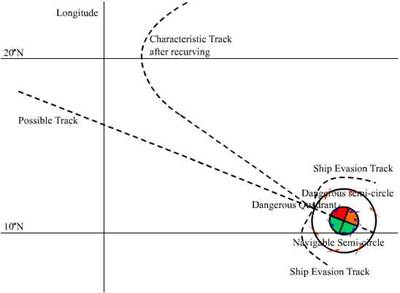
Diagrams below show typical
paths of tropical storms and illustrates the terms dangerous and
navigable semicircle. The former lies on the side of the path towards the usual
direction of recurvature, i.e. the right hand
semicircle in the N and the left hand semicircle in the S hemisphere.
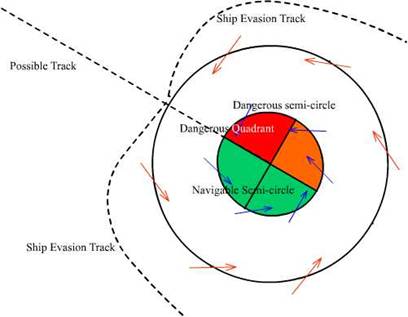
The advance quadrant of the dangerous semicircle(shown in red) is known as the dangerous quadrant
as this quadrant lies ahead of the centre. The navigable semi- circle is that
which lies on the other side of the path. A ship situated within this
semicircle will tend to be blown away from the storm centre and re-curvature of
the storm will increase her distance from the centre.
Avoiding tropical storms.
In whatever situation a ship may find herself the
matter of vital importance is to avoid passing within 50 miles or so of the
centre of the storm. It is preferable but not always possible to keep outside a
distance of 200 miles.
If a ship has at least 20 knots, at her disposal and
shapes a course that will take her most rapidly away from the storm before the
wind has increased above the point at which her movement becomes restricted, it
is seldom that she will come to any harm. Sometimes a tropical storm moves so
slowly that a vessel, if ahead of it, can easily outpace it or, if astern of
it, can overtake it.
If a storm is suspected in the vicinity, the vessel, whilst
observing her barometer, should continue on her course until the barometer has
fallen 5 millibars (corrected for diurnal variation)
below normal, or the wind has increased to force 6 when the barometer has
fallen at least 3 millibars.
Then she should act as recommended in the paragraphs
below, until the barometer has risen above the limit just given and the wind
has decreased below force 6.
Should it be certain, however, that the vessel is
behind the storm, or in the navigable semicircle, it will evidently be
sufficient to alter course away from the centre.
In the N
hemisphere (ship initially moving Slowly).
(a) If the wind
is veering the ship must be in the dangerous semicircle. The ship should proceed with all available
speed with the wind 10° to 45°, depending on speed, on the starboard bow. As the wind veers the ship should turn to
starboard, thereby tracing a course relative to the storm as shown in the above
diagram.
(b) If the wind
remains steady in direction, or if it backs, so that the ship seems to be
nearly in the path or in the navigable semicircle respectively, the ship should
bring the wind well on the starboard quarter and proceed with all available
speed. As the wind backs the ship should
turn to port as shown.
In the S
hemisphere (ship initially moving slowly).
(a) If the wind
is backing the ship must be in the dangerous semicircle. The ship should proceed with all available
speed with the wind 10° to 45° depending on speed, on the port bow. As the wind backs the ship should turn to
port thereby tracing a course relative to the storm as shown.
(b) If the wind
remains steady in direction, or if it veers, so that the ship seems to be
nearly in the path or in the navigable semicircle respectively, the ship should
bring the wind well on the port quarter and proceed with all available
speed. As the wind veers the ship should
turn to starboard as shown.
If there is insufficient sea room to run, when in the
navigable semicircle, and it is not practicable to seek shelter, the ship should
heave to with the wind on her starboard bow in the N and on her port bow in the
S hemisphere.
If in harbour when a tropical storm approaches,
it is preferable to put to sea if this can be done in time to avoid the worst
of the storm. Riding out a tropical
storm, the centre of which passes within 50 miles or so, in a harbour or anchorage, even if some shelter is offered, is
an unpleasant and hazardous experience, especially if there are other ships in
company. Even if berthed alongside, or
if special moorings are used, a ship cannot feel entirely secure.