| Sailings | Chart Work Exercises | Information from Charts | Tides | Sextant |
Terrestrial Navigation
Position Lines and Positions
A ‘Fix’ is
the name given to a position obtained of a ship relatively to a shore objects.
Dead reckoning (DR) determines position by advancing a
known position for courses and distances.
A position so determined is called a dead reckoning
(DR) position.
It is generally accepted that only course and speed
determine the DR position. Correcting the DR position for leeway, current
effects, and steering error result in an estimated position (EP).
An inertial navigation system gives an extremely
accurate EP.
Piloting involves navigating in restricted waters with
frequent determination of position relative to geographic and hydrographic
features.
Celestial navigation involves reducing celestial
measurements to lines of position using tables, spherical trigonometry, and
almanacs. It is used primarily as a backup to satellite and other electronic
systems in the open ocean.
Coastal navigation involves using visual sight of
lighthouses and other prominent marks (conspic.),
taking their bearings and estimating their distances with either RADAR or by
using the vertical angle obtained with a sextant. Horizontal sextant angles may
also be used – however this practice has practically died down with the advent
of Very large ships, sophisticated RADAR, GPS and mainly through lack of
practice by seafarers.
Radar navigation uses radar to determine the distance
from or bearing of objects whose position is known. This process is separate
from radar’s use as a collision avoidance system.
Satellite navigation uses artificial earth satellites
for determination of position.
Four
distinct phases define the navigation process.
Depending on the type of passage the phase of position
fixing should be adopted.
Pilotage Waters: Piloting in narrow canals, channels,
rivers, and estuaries.
Harbour Approaches: Navigating to a harbour entrance
and piloting in harbour approach channels with or without a pilot.
Coastal passage: Navigating within 50 miles of the
coast or inshore of the 200-meter depth contour.
Ocean Passage: Navigating outside the coastal area in
the open sea.
The navigator’s position accuracy requirements, his
fix interval, and his systems requirements differ in each stage of the passage.
The
Importance Of Dead Reckoning
Dead reckoning allows a navigator to determine his
present position by projecting his past courses steered and speeds over ground
from a known past position. He can also determine his future position by
projecting an ordered course and speed of advance from a known present
position.
The DR position is only an approximate position
because it does not allow for the effect of leeway, current, helmsman error, or
gyro error.
Dead reckoning helps in determining sunrise and
sunset; in predicting landfall, sighting lights and predicting arrival times;
and in evaluating the accuracy of electronic positioning information. It also
helps in predicting which celestial bodies will be available for future
observation.
The navigator should carefully tend his DR plot,
update it when required, use it to evaluate external forces acting on his ship,
and consult it to avoid potential navigation hazards.
THE RULES
OF DEAD RECKONING
Plotting The DR
Plot the vessel’s DR position:
1. At least every hour on the hour.
2. After every change of
course or speed.
3. After every fix or running
fix.
4. After plotting a single line of position.
Fix Expansion

Often a ship steams in the open ocean for extended
periods without a fix. This can result from of any number of factors ranging
from the inability to obtain celestial fixes to malfunctioning electronic
navigation systems. Whatever the reason, in some instances a
navigator may find himself in the position of having to steam many hours on DR
alone.
The navigator must take precautions to ensure that all
hazards to navigation along his path are accounted for by the approximate
nature of a DR position.
One method, which can be used, is fix expansion.
Fix expansion takes into account possible errors in
the DR calculation caused by factors, which tend to affect the vessel’s actual
course and speed over ground. The navigator considers all such factors and
develops an expanding “error circle” around the DR plot. One of the basic
assumptions of fix expansion is that the various individual effects of current,
leeway, and steering error combine to cause a cumulative error, which increases
over time, hence, the concept of expansion.
Errors considered in the calculation of the fix
expansion encompass all errors that can lead to DR inaccuracy. Some of the most
important factors are current and wind, compass or gyro error, and steering
error. Any method which attempts to determine an error circle must take these
factors into account. The navigator can use the magnitude of set and drift calculated
from his DR plot. He can obtain the current’s magnitude from pilot charts or
weather reports. He can determine wind speed from weather reports or direct
measurement. He can determine compass error by comparison with an accurate
standard or by obtaining an azimuth of the sun. The navigator
determines the effect each of these errors has on his course and speed
over ground, and applies that error to the fix expansion calculation.
As noted above, the error is a function of time; it grows as the ship proceeds down the track without a obtaining a fix. Therefore, the navigator must incorporate his calculated errors into an error circle whose radius grows with time. For example, assume the navigator calculates that all the various sources of error can create a cumulative position error of no more than 2 nm. Then his fix expansion error circle would grow at that rate; it would be 2 nm after the first hour, 4 nm after the second, and so on.
At what value should the navigator start this error
circle?
Recall that a DR is laid out from every fix. All fix
sources have a finite absolute accuracy, and the initial error circle should
reflect that accuracy. Assume, for example, that a satellite navigation system
has an accuracy of 0.5 nm.
Then the initial error circle around that fix should
be set at 0.5 nm.
Construct the error circle as follows. When the
navigator obtains a fix, reset the DR to that fix. Then, enclose that DR
position in a circle the radius of which is equal to the accuracy of the system
used to obtain the fix. Lay out the ordered course and speed from the fix
position. Then, apply the fix expansion circle to the hourly DR’s. In the
example given above, the DR after one hour would be enclosed by a circle of
radius 2.5 nm, after two hours 4.5 nm, and so on. Having encircled the
four-hour DR positions with the error circles, the navigator then draws two
lines originating tangent to the original error circle and simultaneously
tangent to the other error circles. The navigator then closely examines the area
between the two tangent lines for hazards to navigation as shown above.
The fix expansion encompasses all the area in which the vessel could be located (as long as all
sources of error are considered). If any hazards are indicated within the cone,
the navigator should be especially alert for those dangers.
If, for example, the fix expansion indicates that the
vessel may be standing into shoal water, continuously monitor the echo sounder.
Similarly, if the fix expansion indicated that the vessel might be approaching
a charted obstruction, post extra lookouts.
The fix expansion may grow at such a rate that it
becomes unwieldy. Obviously, if the fix expansion grows to cover too large an
area, it has lost its usefulness as a tool for the navigator, and he should
obtain a new fix.
DETERMINING
AN ESTIMATED POSITION
An estimated position is a DR position corrected for
the effects of leeway, steering error, and current. This section will briefly
discuss the factors that cause the DR position to diverge from the vessel’s
actual position. It will then discuss calculating set and drift and applying
these values to the DR to obtain an estimated position. Finally, it will
discuss determining the estimated course and speed made good.
Factors
Affecting DR Position Accuracy
Tidal current is the periodic horizontal movement of
the water’s surface caused by the tide-affecting gravitational force of the
moon. Current is the horizontal movement of the sea surface caused by
meteorological, oceanographic, or topographical effects. From whatever its
source, the horizontal motion of the sea’s surface is an important dynamic
force acting on a vessel moving through the water.
Plotting
Position:
The most common means of fixing a vessel in earlier
times and even today without the assistance of Radar,
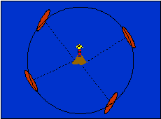
is by taking three bearings and crossing them to obtain the ships position.
The only requirement in this type of fixing is the
separation angle between the points taken up for use.
If the angle between any two points is close to 90°
then the fix may be considered to have a higher accuracy than if the
intersecting angles are less than 90°. As the intersecting angles become lesser
than 90° the fix accuracy decreases.
Points that may be taken up are the obvious choices
like Light Houses, beacons etc. Also points, which may be taken up, are edge of
land if sharp and the edge is a cliff, conspicuous hilltops. Buoys are not
suitable for accurate fixing since a buoy at close range swings somewhat and
may also have drifted slightly.
When plotting on the chart the small circle at the
base of the beacon or buoy is the reference point from which to draw the
bearing line.

The Radar distance off from a Lt. Ho., once the
distance off has been noted the navigator may draw a circle of position on the
chart, the centre of the circle being the point of interest. All ships with the
same distance off will be on the position circle, and a ship will not be able
to determine her position unless another position circle is drawn from another
charted radar target or a bearing of the point of interest is also taken.
Plotting a
position on the chart from simultaneous cross bearings and from a bearing and
distance off
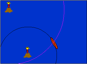
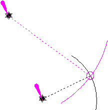
Above shows two simultaneous distance
off’s from two different point of interest
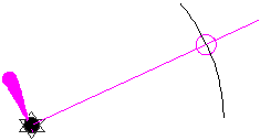
Above shows a single object providing a distance off
and the same object providing the bearing to plot a position.
Plotting And Labelling The Course Line And Positions

Draw a new course line whenever restarting the DR.
Extend the course line from a fix in the direction of the ordered course. Above
the course line place a capital C followed by the ordered course. Below the
course line, place a capital S followed by the speed in knots. Label all course
lines and fixes soon after plotting them because a conning officer or navigator
can easily misinterpret an unlabeled line or position.
Enclose a fix from two or more LOPs
by a small circle and label it with the time to the nearest minute. Mark a DR
position with a semicircle and the time. Mark an estimated position (EP) by a
small square and the time. Determining an EP is covered later in this chapter.
Express the time using four digits without
punctuation.
Use either zonetime or GMT.
Label the plot neatly, succinctly, and clearly.
The above figure illustrates this process. The 2nd. Officer plots and labels the 0806
observation of the sun’s longitude and the PL. The Master orders a course of
095°T and a speed of 15 knots. The 2nd.
Officer extends the course line from 0806 in a direction of 095°T. He
calculates that in 1 hour and 54 minutes at 15 knots he will travel 28.5
nautical miles. He measures 28.5 nautical miles from the 0806 position along
the course line and marks that point on the course line with a cross. He labels
this DR with the time.
DANGER
ANGLES – VERTICAL AND HORIZONTAL
Not normally used today and the student
are referred to read about the same from the notes on Sextant and from the
Nichols Concise Guide.