| Sailings | Chart Work Exercises | Information from Charts | Tides | Sextant |
Terrestrial Navigation
Chartwork Exercises
Distance
Distance, as used by the navigator, is the length of
the rhumb line connecting two places. This is a line making the same angle with
all meridians. Meridians and parallels, which also maintain constant true
directions, may be considered special cases of the rhumb line. Any other rhumb
line spirals toward the pole, forming a loxodromic
curve or loxodrome.
Distance along the great circle connecting two points
is customarily designated great-circle distance. For most purposes, considering
the nautical mile the length of one minute of latitude introduces no
significant error.
Heading
Heading
(SH) is the direction in which a vessel is pointed, expressed as angular
distance from 000˚clockwise through 360˚.
Do not confuse heading and course.
Heading constantly changes as a vessel yaws back and
forth across the course due to sea, wind, and steering error. While the course
to be steered or steered is constant.
Bearing (Brg.) is the
direction of one terrestrial point from another, expressed as angular distance
from 000˚(North) clockwise through
360˚. When measured through 90˚or 180˚from
either north or south, it is called bearing angle (B). Bearing and azimuth are
sometimes used interchangeably, but the latter more accurately refers to the
horizontal direction of a point on the celestial sphere from a point on the
earth. A relative bearing is measured relative to the ship’s heading from
000˚(dead ahead) clockwise through
360˚. However, it is sometimes conveniently measured right or left from
0˚at the ship’s head through 180˚.
This is particularly true when using the table for
Distance of an Object by Two Bearings.
To convert a relative bearing to a true bearing, add
the true heading:
True Bearing = Relative Bearing + True Heading.
Relative Bearing = True Bearing – True Heading.
Relative bearings are sometimes termed RED (0° to
180°) for port and GREEN (0° to 180°) for starboard.
For example: On a course of 125°T and the ships bridge
wing repeaters not working, the bearing may still be taken – by using the
PELORUS ring.
A object is selected and the relative bearing is read
on the brass ring, the bearing may be 30° on the port side of the Fore and aft
line of the ship. It is then called as RED 30°.
To convert: True Bearing = Ships Head - 30°
=
SH - 30° or 125 – 30 = 095°T
Similarly if the object were on the starboard side of
the fore and aft line of the ship, then with the same bearing it would be
called as GREEN 30°, to convert:
True Bearing = Ships Head + 30°
= SH + 30°
or 125 + 30 = 155°T
Set and Drift
Set refers to the current’s direction, and drift
refers to the current’s speed.
Leeway is the leeward motion of a vessel due to that
component of the wind vector perpendicular to the vessel’s track.
Leeway and current effects combine to produce the most
pronounced natural dynamic effects on a transiting vessel.
In addition to these natural forces, helmsman error
and gyro error combine to produce a steering error that causes additional error
in the DR.
Calculating
Set And Drift And Plotting An Estimated Position
It is difficult to quantify the errors discussed above
individually. However, the navigator can easily quantify their cumulative
effect by comparing simultaneous fix and DR positions. Were there no dynamic
forces acting on the vessel and no steering error, the DR position and the fix
position would coincide. However, they seldom coincide. The fix is offset from
the DR by a finite distance.
This offset is caused by the error factors discussed
above.
Note again that this methodology provides no means to
determine the magnitude of the individual errors. It simply provides the
navigator with a measurable representation of their combined effect.
When the navigator measures this combined effect, he
often refers to it as the “set and drift.” Recall from above that these terms
technically were restricted to describing current effects. However, even though
the fix-to-DR offset is caused by effects in addition to the current, here it
is assumed the offset as the set and drift.
The set is the direction from the DR to the fix. The
drift is the distance in miles between the DR and the fix divided by the number
of hours since the DR was last reset. This is true regardless
of the number of changes of course or speed since the last fix.
Calculate set and drift at every fix.
Leeway:
Leeway is the effect of the wind on the
course of a ship.
A ship sails along a course line from
point A towards point B, if there were no wind and no current then the ship
would be at point B after a certain amount of time.
However if there
is some wind and that affects the ship in keeping her course then she would be
sailing a slightly different course. The effect would be
that she would be off her destination point either in time or in distance away.
To find out and allow leeway:
Face in the direction of the ships
heading, and if the wind is from the right side then the leeway to be applied
is to the left.
Leeway is termed (+) when the wind is to
the Port side of the ship and (-) when the wind is on the starboard side of the
ship
Estimated
Course And Speed Made Good
The direction of a straight line from the last fix to
the EP is the estimated track made good. The length of this line divided by the
time between the fix and the EP is the estimated speed made good.
Measuring
Courses And Distances
To measure courses, use the chart’s compass rose
nearest to the chart section currently in use. Transfer course lines to and
from the compass rose using parallel rulers, rolling rulers, or triangles.
The navigator can measure direction at any convenient
place on a Mercator chart because the meridians are parallel to each other and
a line making an angle with any one makes the same angle with all others. Measure direction on a conformal chart having nonparallel meridians
at the meridian closest to the area of the chart in use. The only common
non-conformal projection used is the gnomonic; a gnomonic chart usually
contains instructions for measuring direction.
Compass roses give both true and magnetic directions.
For most purposes, use true directions.
Measure distances using the chart’s latitude scale.
Assuming that one-minute of latitude equals one nautical mile introduces no
significant error. Since the Mercator latitude scale expands as latitude
increases, measure distances on the latitude scale closest to the area of
interest. On large scale charts, such as harbour charts, use the distance scale
provided.
To measure long distances on small-scale charts, break
the distance into a number of segments and measure each segment at its
mid-latitude.
Navigational computers can also compute distances
between two points. Because of the errors inherent in manually measuring track
distances, use a navigation computer if one is available.
Fixing the ship using only bearings
Doubling The Angle At The Bow
The basis of this method is to take advantage of
geometry – an isosceles triangle.
The bearing of a point is noted preferably fine on the
bow, the angle is doubled and a wait ensues, as the vessel proceeds along her
course, the time that the point bears the double of the 1st bearing
is noted.
Then the distance traveled during the time period from
1st bearing to the time of the 2nd (double the angle)
bearing is the distance that the vessel is off the point at the time of the 2nd
bearing.
Further calculation will give the beam distance,
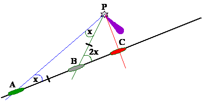
In the above figure, the position of the ship when she
takes the 1st bearing is A, at the 2nd position it is B
and when abeam the ship is at C.
The angle at A is half that of the angle at B, this
gives that the distance BP = AB the distance run by the ship.
Knowing the angle at B and the side BP, we can find
the distance when abeam PC.
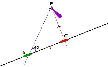
Another
method – Four Point Bearing:
In this the above exercise is carried out with a difference.
The difference being that the 1st angle is 45˚ (four points)
and the 2nd bearing is 90˚ (double of the 1st
bearing),
But 90˚ on the bow is also the beam distance,
thus it gives the beam distance as the distance run between the 1st
and the 2nd bearings. The only disadvantage in this is that the beam
distance is known when the vessel is actually abeam.
However it does help since
it gives and indication of the distance that is going to be when abeam by the
time that is elapsed between the 1st and the 2nd
bearings.
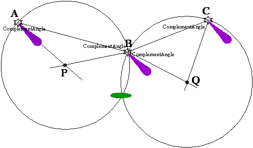
Running
Fix:
In this case only one object is used to obtain the
vessel’s position, though not an accurate one.
Used when only one prominent object
is available for fixing the position of the vessel.
Today with the advent of Radar navigation, this method
is rarely used. However in case both the radar’s fail, and the navigator has to
rely on fixes (visual) to navigate then the above would come in handy.
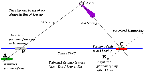
In the above figure, the ship has a Light House in
view and takes a bearing at 0800hrs.
She then proceeds on her course of 090°T for a period
of 1 hour at a speed of 13knots.
Thus the distance covered is 13NM.
She thus starts from the position A and arrives at
position B after doing 13NM.
The first bearing is transferred to B and a new
bearing is taken, where both intersect is the position of the ship. If we now
draw a line parallel to the course line from the actual position of the ship at
2nd bearing, C, then the 1st actual position would be the
point P.
If there is a current being experienced then the
entire estimated course and the distance traveled will have to be first deduced
and then the above may be done.
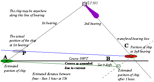
Draw the course line from A to B; allow the set and
the drift of the current at position B.
Then this would be the estimated track of the ship
after this the 1st and the 2nd bearing parts become as
described earlier.
There are some special angles which give the distance
off that a ship will pass when abeam of a point, however the number
of such special angles are limited and the student is asked to refer to
– Nicholls’s Concise Guide for further reading.
Sextant
Angles:
Before the advent of Radar, the sextant was a handy
instrument from taking celestial angles to taking terrestrial angles. The
sextant was used to find the distance off from lighthouses as well as for
fixing the position of the ship without using the compass.
For finding the distance off from Lt Houses and high
conspicuous hilltops the vertical sextant angle was used in conjunction with a
bearing fixed the position of a ship.
The horizontal sextant angle was used when two or more
prominent points were available and the position of the ship was fixed without
using a bearing.
Vertical
Sextant Angle:
The angle subtended by the top and bottom
of the object at the observer is noted and the angle is corrected for Dip and
IE.
The corrected angle is then used with the
height of the object to obtain the distance off from the object.
The expression used is:
Distance
Off in NM = Height of the object in feet x
0.565
Vertical
sextant angle in minutes
Horizontal
Sextant Angles:
For use in
position fixing without the aid of a compass.
Three conspicuous points are selected, ensure that the angles that they subtend are wide.
The sextant is held horizontally and the
sextant angle between point A and point B is obtained.
Then the sextant is used to obtain the
angle between points B and C.
Straight lines are drawn between points A
to B, and again between points B to C.
Say the angle obtained between A and B is
58°, therefore the complement is 32°, (90-58)
Also say the angle obtained between B (2nd
instance) and C is 42°, therefore the complement is 48°, (90-42)
Using the parallel ruler lines are drawn
with the complement angles from the respective points.
Point A: 32° and point B: 32° - first
position circle
Point B: 48° and point C: 48° - second
position circle
Case 1
The intersection of the complement lines
from A and B intersect at point P, this would be the centre of the position
circle, touching the points A and B and the ship is on this circle.
Case 2
The intersection of the complement lines
from B (2nd instance) and C intersect at point Q, this would be the
centre of the position circle, touching the points B and C and the ship is on
this circle.
The point of intersection of the two
circles is then common and so the ship is at that position.
Visibility
of Lights:
Lights are placed on Light Houses at a
height of the light houses, depending on the intensity of the lights
themselves, the lights are marked as visible up to a distance of a certain
limit, the height of the observer when declaring the above is taken to be 15
feet.
However the visibility of the lights at
the marked limit may be exceeded due to the height of the ship also.
The expression for obtaining the raising
of the light limit is given by:
Heights in feet
Distance = (√Height of observer x
1.15) + (√Height
of Object x 1.15)